
Hiking Waubonsie State Park, Iowa

We had no idea we’d find undulating hills in Iowa at Waubonsie State Park. The map of our hike in Iowa is at the bottom of this post.
After two flat hikes in a row, one in Oklahoma and the other in Kansas, our Colorado legs were itching for some ups and downs on our 50 Hikes 50 States Hiking Project. With Iowa being our destination for the day, I didn’t have high hopes for high climbs. We enjoyed a hike nearby Council Bluffs.
But, wow, did Iowa surprise us!
Where Do Truckers Exercise?

We had to hustle. Our drive up from Oklahoma through Kansas to get to Iowa put us in Percival, Iowa at dinner time. Percival is a dot; not even a dot; a tiny speck in the corner of southwest Iowa, catering to the many truckers going up and down the spine of the midwest. It was too late to hike, so we would have to squeeze a sunrise hike in on Sunday to catch our 11:00 flight out of Omaha. In the meantime, we pondered our “tiring” view outside our hotel window.
Our dinner choices were a truck diner and a Wendy’s. Normally I’d settle for some eggs and hash browns at the diner, but they were only serving dinner. Passing on the country fried steak, pork chops, and lasagna options, which all looked great but were loaded with meat and meat products, I settled for a yummy baked potato at Wendy’s with a side of almonds. You win some. You lose some.
After our dinner, we decided to peruse the giant parking lot. Over 200 trucks idled, settling into their nightly routine. A few Asplundh trucks with their cherry picking arms rolled in on their way to clean up hurricane damage in New Orleans. From the cabs of the semis, we could see the glow of screens where tired truckers watched movies and news. A few were on phones catching up with friends, bosses, and loved ones.
All I could think about was where do these guys get a chance to work out and exercise? Why aren’t there gyms in the truck stops next to the showers? Do they socialize at all? If you’re a trucker, help me with these questions, please.
A Sunrise Hike in Iowa

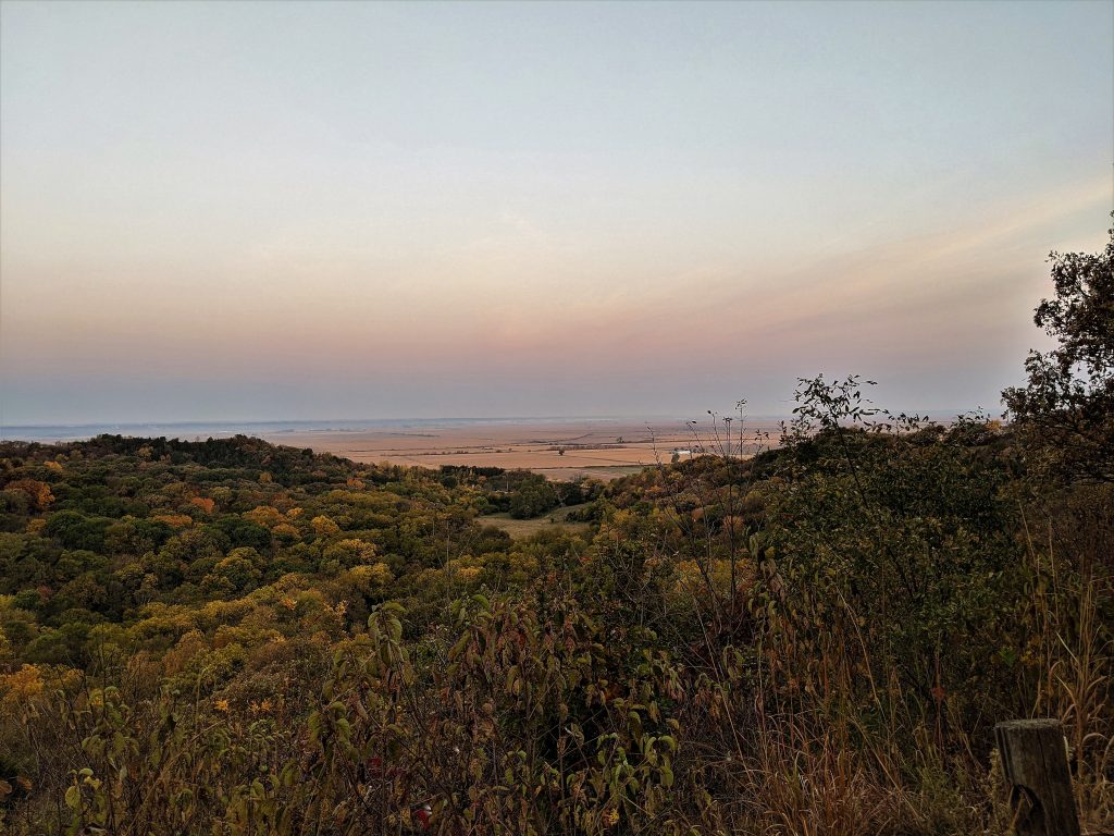
Our alarm jolted us up at 5:30. At the truck stop we grabbed breakfast burritos since our fancy Super 8 wasn’t serving any breakfast items due to Covid, and then we drove just 10 minutes to the Waubonsie State Park. Up into the Loess Hills we drove as the sun started to wake up. The Loess Hills are a hill formation made from blowing dust that runs from the westernmost parts of Iowa and Missouri, and the easternmost parts of Nebraska and Kansas, along the Missouri River.
We found ourselves at the trailhead to the Sunset Ridge Trail right as the sun was rising to the east. From this point, Lewis and Clark looked out to the Missouri valley and across the Nebraska plains to track a path west. We could almost see Council Bluffs and the Lewis and Clark National Historic Trail Visitors Center.
Chief Wabaunsee of Potawatomi tribe, from whom the park gets its name, signed many treaties with the US government regarding land and fiercely lead his tribe in many battles.
What a juxtaposition!
Sunrise Over Nebraska
With the sun to our backs, we headed down the trail. Immediately, I was in awe of the sparkling fall colors from the oaks, birch, maples and other deciduous trees. Enjoy the video below of the leaf tunnel we enjoyed.
The trail meandered along the ridge, overlooking the Missouri valley. The sun started to reflect out into the plains, as we watched pinks turn to blues across the wide open views that went for possibly hundreds of miles. Soon, the trail rounded the point. Then it ducked down into a canyon and started a steep decline.
I guess in a land where a straight path will take you for thousands of miles without needing to accommodate for elevation gains, trail builders tend to think in straight lines. I don’t think I’ve ever hiked down and then back up the side of a 200 foot hill without a switchback or two. Not here. Straight down we went.
Yeti Lives Here?

Yet before going up, we came across a Hobbit house, bomb shelter, tomb, or Yeti’s house. We’re not sure which, as there was no signage letting us know about our discovery. Clearly people have used it to seek a break from the heat or cold, as there was evidence of a campfire inside.
Then, straight back up the side of the hill we went. A slight detour rerouted us, but I think it was temporary due to a washout. I hope the trail maintenance folks will figure out a way to install some steps or some switchbacks to make this trail a bit more manageable for more hikers.

Roughly following the trail markers, we ended up back on the interior park road leading to our car. With just a few extra minutes to spare, we decided to drive through the camp ground. It was filled to the rafters with the beginning of the snow bird crowd, with tents and RVs spilling their doodads and knick knacks out into the world.
Just Dipping Our Toes in Iowa

Sadly, our trip to Iowa ended without a visit to any Visitor Centers nor any interesting Iowa city. We nary had time to spare for a stop in Council Bluffs. But the ride to the airport did take us through a corner of Omaha, Nebraska. Next time, we’ll plan a bit more time to explore some of the Lewis and Clark history, especially since our midwestern hikes (see Missouri) certainly touched on their impact to western expansion (see Nebraska.)
What You Need to Know about This Hike (click for interactive map)

Chris Englert, the Walking Traveler, believes walking is the platform for life. Wanderlusting since the age of 5, she’s since traveled all 50 US states and 62 countries. Chris shares her love of walking while traveling via blogs, books, and presentations. A natural storyteller, she invites you along as she explores the world, one walk at a time.
Currently, Chris and her husband, Steve, travel the world, full-time as nomads, with just their two carry-ons. They’ve been traveling since May, 2021.